Global Journal of Ecology
Identification of suitable location for construction of check dam in Manur water shedding area, Tirunelveli District
Gopikumar S1*, Sundararajan S2, Allwyn Kingsly Gladston J2, Antony Vasantha Kumar C2, Hari Babu K2 and Jeyakumar K2
2Department of Mechanical Engineering, SCAD College of Engineering & Technology, India
Cite this as
Gopikumar S, Sundararajan S, Allwyn Kingsly Gladston J, Antony Vasantha Kumar C, Hari Babu K (2021) Identification of suitable location for construction of check dam in Manur water shedding area, Tirunelveli District. Glob J Ecol 6(1): 046-050. DOI: 10.17352/gje.000043In this research article author has focused on the issue of ground water and narrated that in modern civilized society the day today usage of ground water for community utility has been raised. As it is clear that due to change in weather condition the predicted monsoon has been changing its seasonal annual rainfall. Furthermore, the it is suggested that a proper technique should be implemented to preserve the available fresh water, which is need of the hour for dry zone like Manur of Tirunelveli district. A suitable techniques has been suggested for real time implementation which is to be demonstrated in a pilot scale. This research work explores all the possibilities to execute the identification of suitable site selection.
Introduction
Rural development, Urbanization and industrialization are developing in modern era with the support of available ground water. Conservation of water resources is a global issue, which has been emerging as a difficult task in the developing countries. Tirunelveli is established with good water resources from the origin of river thamirabarani, meanwhile manur taluk has been observed to be dryzone with lesser water storing capability [1]. Considereing the fact it is planned to raise the ground water storage with the support of identifying suitable location for the construction of check dams in the region, where the draing excess river water may be preserved. While focusing on geological parameters in these areas it has clay soil also called as black cotton soil, which has a very good potential to store ground water [2]. The real need for the dry zone is adopting a suitable technique for water conservation implemention.
In recent days construction of sub surface dam has been emerging in most part of the world for temporary storage of groung water, which may be utilized for cattle feeding and day today utility [3]. The most crucial part in this work is identification of location, where a vast parameters are to be typically considered for fixation. Comparatively it is assessed that each area has unique quality with distinguished advantages and disadvantages, but priority is given for the possibility of reducing the evaporation potential of water [4].
Multi-Criteria Decision-Making Method (MCDM) works on the principle of choosing different criteria and each paramaters have been measured in terms of quantity and quality. The major factors took into considerations are earth study, hydro geological study and financial contribution, meanwhile they have been given weightage and based on optimization suitable region is finalized [5]. In this project work, 14 different locations have been identified as possible zones and decision making strategies have been incorporated. The ranking of parameters have been established with the support of dissimilar ELECTRE. Outcome from different ELECTRE have been categorized and ranked, further they may be merged with Borda and Copeland approach.
Finally this project work will give a solution for the preservation of shedding freshwater to the sea with more detailed field investigations and manur taluk is always identified as the best study location based on GIS information.
Literature survey
Subsurface dams or check dams are normally constructed to safeguard the available water resource within their limit [6]. In general the purpose of these check dams are to provide livelihood for the living being in and around the zone, that are brought up with the support of rural development fund allocations and resources availability. These structures have been proved to be effective for decades and has been established as life saving factors. Some of the examples of subsurface dams are the elevation of Sardinia in rome, ancient civilization of african [7]. In modern days with the support of advanced techniques the establishment of check dams are coming up in great height in India and Africa [8]. Normally these check dams will block the intrusion of salt water to their region and keep the fresh water lively for long time [9]. Multi-criteria decision making MCDM analyses are highly recommended for the usage of contemporary water shortage crisis [10]. FAHP has been recognized as effective in identification of location for the construction of subsurface dams. In addition the application of Boolean and fuzzy logic [11]. along with FTOPSIS and EDAS [12]. have been identified as distinguished methodologies for assessment of suitable locations. Considering the innovation part it is always accepted that Multi-criteria decision making techniques are distinguished in all aspects of rankings and the optimized outcome has been unique in results, which are highly recommendable.
Objectives
1. To encourage contemporary and systematic method in identification of sub surface dam site construction
2. To involve in eradication of wasted fresh water to sea by research application in reclaiming water.
Methodology
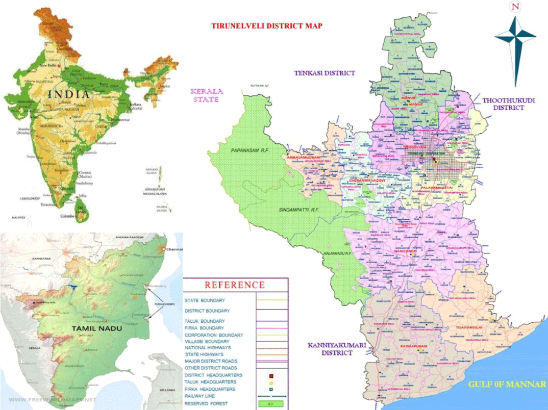
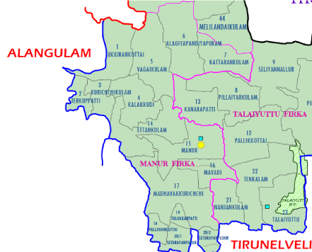
Manur Taluk comprises of 14 villages named ukkirankottai, therkkupatti, Kurichikulam, Kalakkudy, Vagaikulam, Alagiapandyapuram, Kattarankulam, Ettankulam, Manur, Mavadi, Madavakurichi, Vallavankottai, Thulukarpatti, Sethurayanpudur. The geological map for evaluating suitable subsurface dams has been incorporated in Figures 1,2.
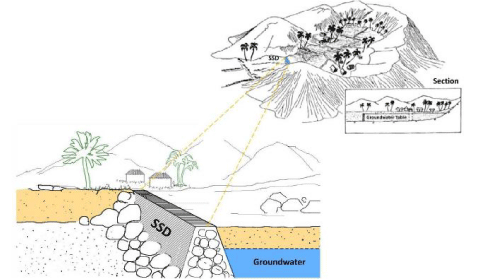
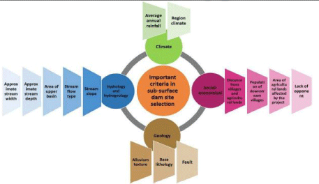
The investigations are carried forward with the geological comparision from spatial database, hydrological assessment with the support of study on hydraulic parameter. The study region has been quantitatively and qualitatively ranked and optimization study has to be progressed with the MCDM analyses. A typical scheme on construction of subsurface dam has been portraited in Figure 3. The parameters required for ranking are highlighted in Figure 4.
The existing river flow towards the watershed area is blocked and an artificial storage unit creation will benefit the community. In this case through an external well may be constructed to draw the stored water, which may be used for a long time during change in weather conditions and this will be an effective practice. With appropriate ground truthing study in the location the modern engineering parameters highlighted in the Figure 4 gives easy solution for categorization and rankings are fixed .
Work plan: Proposed structure details
Using grade average strategies the final ranking of the sites are to be fixed. Four factors such as climatic, geological, hydrological and socio-economic are to be given importance for identified villages of manur taluk. With the support of hydrogeological data and MCDM analysis the optimum area are to be selected and finalize for the subsurface dam or check dam construction.
From the source classified parameters, individual secondary categorization has been identified and given weightage that will carry forward for the detailed study. The possible associated criterion are rainfall, local weather condition, level of stream flow, slope from the origin of river, detailing the depth and width of stream, the outer cover basin, alluvium texture, the load to base lithology, liability, coverage on agricultural land to village, inhabitants of down stream villages, cultivation land affects due to this projet and lack of opponent. From this data mean geometric value has been optimized using different experts opinion through matrix study. The relative weightage and approximation has been finalized with eigen vector and geometric mean method, where the final weightage are fixed with fuzzy logics.
Decision matrix for stronger and weaker choice against the factors are listed and threshold on final comparison dominance matrix is framed for effective preparation of rankings. From this it has been optimized that Manur is the potential location for constructing a check dam.
Budget particulars (In Rupees) for pilot model
A. Equipment B. Utility B.1 Consumables Other detailsAny other details
Personnel and facilities
Students – Check Dam site selection (Design) team members
Faculty – Dr. S. Gopikumar is the advisor for this project.
Space - Project work design and pilot model will be completed in the Civil Engineering lab.
Equipment – Concrete lab equipment for compression test tests.
Conclusion
To conclude the existing work there requires a diverse quantity of datas in all stages of investigations. The optimized area for this work among all the zones has been evaluated and identifies manur village as optimized location for construction of checkdam.
- Gopikumar S, Sundararajan S, Gladston JAK, Kumar CAV, Babu KH (2021) A Quantitative Study of Hydraulic Parameters of Thamirabarani River. Austin J Environ Toxicol 7: 1034. Link: https://bit.ly/3fVdnOW
- Owamah H, Alfa M, Oyebisi S, Emenike P, Otuaro E, et al. (2020) Groundwater quality monitoring and perception issues in a popular Niger Delta university town in Nigeria. Groundwater for Sustainable Development 12: 100503. Link: https://bit.ly/3pcD3Lr
- Gopikumar S, Raja S, Harold Robinson Y, Shanmuganathan V, Rho S (2020) A Method of Landfill Leachate management using Internet of Things for Sustainable Smart city development. Sustainable Cities and Society 66: 102521. Link: https://bit.ly/3uxeObR
- Joemax Agu M, Gopikumar S, Vimal S, Harold Robinson Y (2020) Failure assessment of pressure vessels made of plain carbon steel by using modified inherent flaw model in DL based industry optimization intelligent processing. Measurement 165: 1-8. https://bit.ly/3uB07nY
- Kumar DM, Gopikumar S, Kumar SA, Khac Uan D, Banu R (2020) Chapter 2, “Constructed Wetland: An Emerging Green Technology for the treatment of Industrial Wastewaters. Emerging Eco Friendly Green Technologies for Wastewater treatment 1: 21-44. Link: https://bit.ly/3oZgkCl
- Jamali IA, Olofsson B, Mörtberg U (2013) Locating suitable sites for the construction of subsurface dams using GIS. Environmental Earth Sciences 70: 2511-2525. Link: https://bit.ly/3i3bClE
- Raju NJ, Reddy TVK, Munirathnam P (2006) Subsurface dams to harvest rainwater—a case study of the Swarnamukhi River basin. Hydrogeology Journal 14: 526-531. Link: https://bit.ly/3fvGaLd
- Hanson G, Nilsson Å (1986) Ground‐Water Dams for Rural‐Water Supplies in Developing Countries. Groundwater 24: 497-506. Link: https://bit.ly/3ieW3aH
- Chang Q, Zheng T, Zheng X, Zhang B, Sun Q, et al. (2019) Effect of subsurface dams on saltwater intrusion and fresh groundwater discharge. Journal of Hydrology 576: 508- 519. Link: https://bit.ly/34tTtW8
- Sheikhipour B, Javadi S, Banihabib ME (2018) A hybrid multiple criteria decision-making model for the sustainable management of aquifers. Environmental Earth Sciences 77: 712. Link: https://bit.ly/3vBhTc3
- Jamali AA, Randhir TO, Nosrati J (2018) Site suitability analysis for subsurface dams using boolean and fuzzy logic in arid watersheds. Journal of Water Resources Planning and Management 144: 04018047. Link: https://bit.ly/3i31A3F
- Kharazi P, Yazdani MR, Khazealpour P (2019) Suitable identification of underground dam locations using decision-making methods in a semi-arid region of Iranian Semnan Plain: Groundwater for Sustainable Development 9: 100240. Link: https://bit.ly/3wKkSin
Article Alerts
Subscribe to our articles alerts and stay tuned.
 This work is licensed under a Creative Commons Attribution 4.0 International License.

 Save to Mendeley
