International Journal of Agricultural Science and Food Technology
Land suitability evaluation for surface irrigation development using parametric evaluation approach: The case of Gudina Wacho watershed, Western Ethiopia
Gebre Gidey Weldeabzgi1*, Tekalign Ketema2, Gezahegn Gashu3 and Sime Deressa1
2Department of Geography and Environmental studies, Dambi Dollo University, Ethiopia
3Department of Natural Resource Management, University of Gondar, Ethiopia
Cite this as
Weldeabzgi GG, Ketema T, Gashu G, Deressa S (2021) Land suitability evaluation for surface irrigation development using parametric evaluation approach: The case of Gudina Wacho watershed, Western Ethiopia. J Agric Sc Food Technol 7(3): 302-309. DOI: 10.17352/2455-815X.000124Copyright
© 2021 Weldeabzgi GG, et al. This is an open-access article distributed under the terms of the Creative Commons Attribution License, which permits unrestricted use, distribution, and reproduction in any medium, provided the original author and source are credited.Evaluating land suitability of a given watershed is vital to predict potential and limitation of the land for surface irrigation. The present study was evaluated the suitability of Gudina Wacho watershed for surface irrigation development using parametric evaluation approach. The watershed was classified in to four lands mapping units, based on three soil profile pits were opened at each land mapping unit. Soil samples from each profile pit have been taken to analyze each selected soil physical and chemical properties. Slop analysis of the watershed was computed from the DEM using GIS technique. Results of the land suitability evaluation for surface irrigation showed that, a total area of 3064 ha (72.6%) was slightly suitable (S3) and area of 1154 ha (27.4%) was currently not suitable (N1). The limiting factors were slop, soil texture and drainage. For all land mapping units, chemical soil parameters such as CaCO3, ECe and pH, and the physical parameter (soil depth) were not limiting factors for surface irrigation in the study watershed. Therefore, the area is potential for irrigation production with some limitations and under proper management it can benefit the local community to meet the food demand. In order to sustainably develop the area for irrigation development; land leveling operation or soil conservation work has to be incorporated to break surface slope and to make it suitable for surface irrigation.
Introduction
Ethiopia is rain fed agriculture dependent country; with limited use of irrigation for agricultural production [1]. It is estimated that more than 90% of the food supply in the country comes from rainfed agriculture [2]. The major problem associated with this rainfed agriculture is the high degree of rainfall variability. Due to this variability, crop failures and food insecurity are frequent in the country [3,4]. Hence, the solution for food insecurity could be provided by comprehensive irrigation development that can lead to overcome the effects of rainfall variability and improve the quality of life for rural population [1,5].
Land suitability evaluation of a given watershed is vital to predict potential and limitation of the land for irrigation [6]. Land evaluation on its soil properties and slop suitability are necessary and important steps in surface irrigation planning [7,8]. Accordingly, Sys, et al. [9], suggested a parametric evaluation approach for surface irrigation suitability evaluation which is concern on soil physical properties (soil texture, soil depth and drainage), soil chemical properties (salinity/alkalinity status such as calcium carbonate content and gypsum content of the soil), and slop. Any land can be classified as suitable (S), or not suitable (N) orders for surface irrigation. Where, suitable order type of land quality is suitable for use with good benefits and not suitable denote land quality which is not enough for suitable outcomes [10]. The rate of the suitability is the function of characterization and alignment of land quality in to orders and classes in the framework of its fitness for irrigation [11,12].
Morphometric parameters of Gudina Wacho watershed was analyzed for surface irrigation development using GIS by Gebre, et al. [12]. The result of the analysis indicates that the watershed is elongated in shape, high runoff discharge and permeable subsoil circumstances. This revealed the watershed is good for surface irrigation on its hydrological status and topographic shape [12]. Although, the study by Gebre, et al. [12] lacks land suitability evaluation, it is important for surface irrigation development. So, to endeavor this gap, the present study was evaluated the suitability of Gudina Wacho watershed for surface irrigation development using its soil and slop parameters of the watershed. The result will recognize to the local government (regional and district land use planners), and it could serve as a base line for researchers and policy makers’ concerning land use planning and management for irrigation.
Materials and methods
Description of the study area
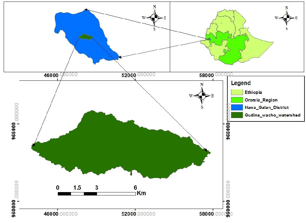
The study was conducted in Gudina Wacho watershed, Hawa Galan district in Kellem Wollega Zone (KWZ) of Oromia Regional State (Figure 1). The district is located 618 km far from Addis Ababa and the capital town of the Zone, Dambi Dollo is found at about 642 km from Addis Ababa. The total land area of the zone is about 9672.4 square kilo meter with altitude ranging above1200m a.s.l. Kellem Wollega zone is bounded by West Wollega Zone in the North, Buno Bedele Zone in the East, Ilu A/Bora Zone in South and Sudan in the West [13].
The climate of the area is a hot and humid type. This region is marked on most rainfall maps of Ethiopia. Ambient temperature of the Zone ranges from 12 – 320C. The annual rain fall of this zone is minimum 1500mm, medium 1900 and maximum 3300 mm [13]. And; the Zone is characterized mostly by flat and undulating land features. The major soil types of the area are Leptosols, Chromic Luvisols, Vertic Cambisols, Dystric Nitisols, Lithosols and Orthic Acrisols [13].
Data types
To achieve the objectives of the study, soil data were collected from the representative pits by field survey, and Shuttle Radar Topographic Mission (SRTM) Digital elevation Model (DEM) with 20-meter spatial resolution of the study area which is widely used for slop analysis was used.
Land mapping units and soil sampling
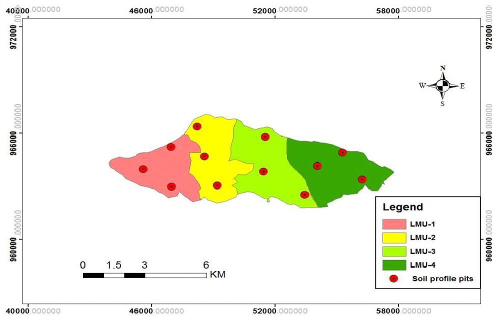
Using Digital elevation Model (DEM) of the study area, the watershed was classified in to four slop classes (land mapping units). Based on the classified slops, three soil profile pits were opened at each land mapping unit (LMU) (Figure 2). In line with this, the profile pits were geo referenced using Global Positioning System (GPS). Soil samples from each profile pit have been taken to analysis each selected soil physical and chemical properties such as texture, CaCO3 status, Electric conductivity (ECe) and pH. In addition, auger observations for soil depth and drainage measurement for soil drainage evaluation on each representative site were made.
Data analysis
Soil parameters analysis and rating for surface irrigation: The selected physical and chemical soil prosperities (soil texture, electrical conductivity and calcium carbonate content) of the watershed were analyzed in laboratory; while soil depth and drainage were measured on fields based on the standards [14]. And, the results were rated according to the guide lines FAO [15] and Sys, et al. [9] for surface irrigation suitability.
Soil texture was determined by the hydrometer method [16]. Electric conductivity of saturation extract (ECe) was determine by 1:2.5 ratio of soil to water suspension using EC meter, and Percentage of calcium carbonate (% CaCO3) was measured using rapide manometric method meter [14]. And, pH (soil reaction) was measured using a glass electrode pH-meter [14].
Slop analysis and rating for surface irrigation: Slop of a given area plays an important role for irrigation activities in general and predominantly in case of surface irrigation. Slop defines if an area is workable at all or not. In the present study, slop was generated from Digital elevation Model (DEM) by means of spatial analyst tool in Arc GIS, and the slop results were rated according to FAO [15] guide line.
Land suitability evaluation: After rated the soil and slop parameters, capability index (Ci) for surface irrigation was calculated using parametric evaluation approach (equation below) [9]. After calculating the capability index, the suitability class for each land unit was given using Table 1 below [9].
Ci=A*B/100*C/100*D/100*E/100*F/100
Where, Ci = Capability index for surface irrigation
A = Rating of soil texture; B = Rating of soil depth; C = Rating of CaCO3 status; D = Rating of electro conductivity; E = Rating of soil drainage; F = Slope rating.
Results and Discussion
Soil parameters evaluation
To evaluate the soil suitability of the watershed for surface irrigation, some selected soil physical properties (texture, depth and drainage) (Table 2) and chemical properties (Caco3 status, Soil salinity and pH) (Table 3) of the watershed were characterized, and rated for surface irrigation (Table 4).
Selected soil physical properties
Soil texture is important factor of soil physical analysis for surface irrigation suitability evaluation as it determines pore spaces of the soil which influence the soil permeability and infiltration rate [15]. In the present study, the soil textural class of the watershed was determined based on the particle size distribution. As a result, percent of clay takes the highest proportion of the soil’s textural class followed by silt and sand. Consequently, the textural class was clay at all land mapping units (Table 2).
Soil depth refers to the thickness of the soil materials which provide structural support, nutrients and water for plants [14]. As it was seen from auger observation and profile description of the soils, soil depths at all sampling points were greater than 100 cm (Table 2), rock out crop was no observed. Hence, the soil in the present study area could be considered as deep soil which is highly suitable for surface irrigation [17].
Soil drainage is also an important factor for land suitability evaluation for surface irrigation as it is treated excess water on surface. Good drainage of the site is essential to allow the continuous movement of water and salt through the profile [14]. Without this continuous leaching, salt may build up to levels that may be harmful to the landscape and crops. In the present study, the soil drainage of the watershed (all land units) was classified as moderately drained (Table 2), which is considered as moderately suitable for surface irrigation [18].
Selected soil chemical properties
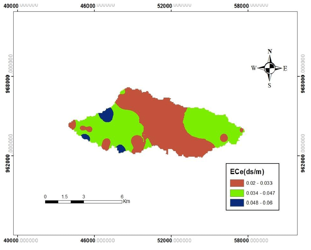
Soil pH results from the laboratory analysis showed that the average soil pH (H2O) values were found in the ranges of 5.74 to 6.04 (Table 3), which was moderate acidic Sys, et al. [9] and the average salinity ranges from 0.03 to 0.04 dS/m (Table 3). Due to the moderately acidic nature of the soils of the study area, the ECe values were negligible. Moreover, there was no significant difference in ECe values. This indicates that there would not be any actual and potential salinity hazard in the soils of the watershed [15].
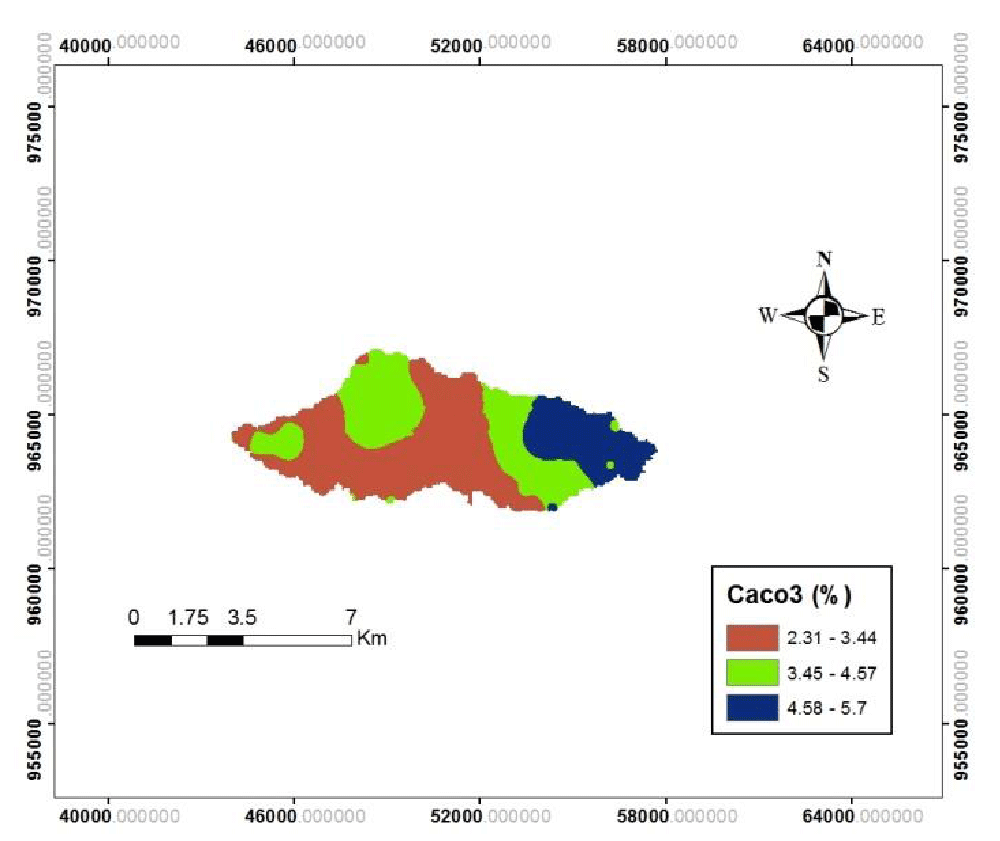
The average soil Calcium carbonate status( CaCO3) values, were found in the ranges of 3.2-5.1 percent. The highest CaCO3 value as 5.1 was observed on land mapping unit four and the lowest as 3.2 was recorded in land mapping unit one (Table 3). Similar results were found in Semaz irrigation Dam by Abram, et al. [18] Figures 3-5.
Slop evaluation
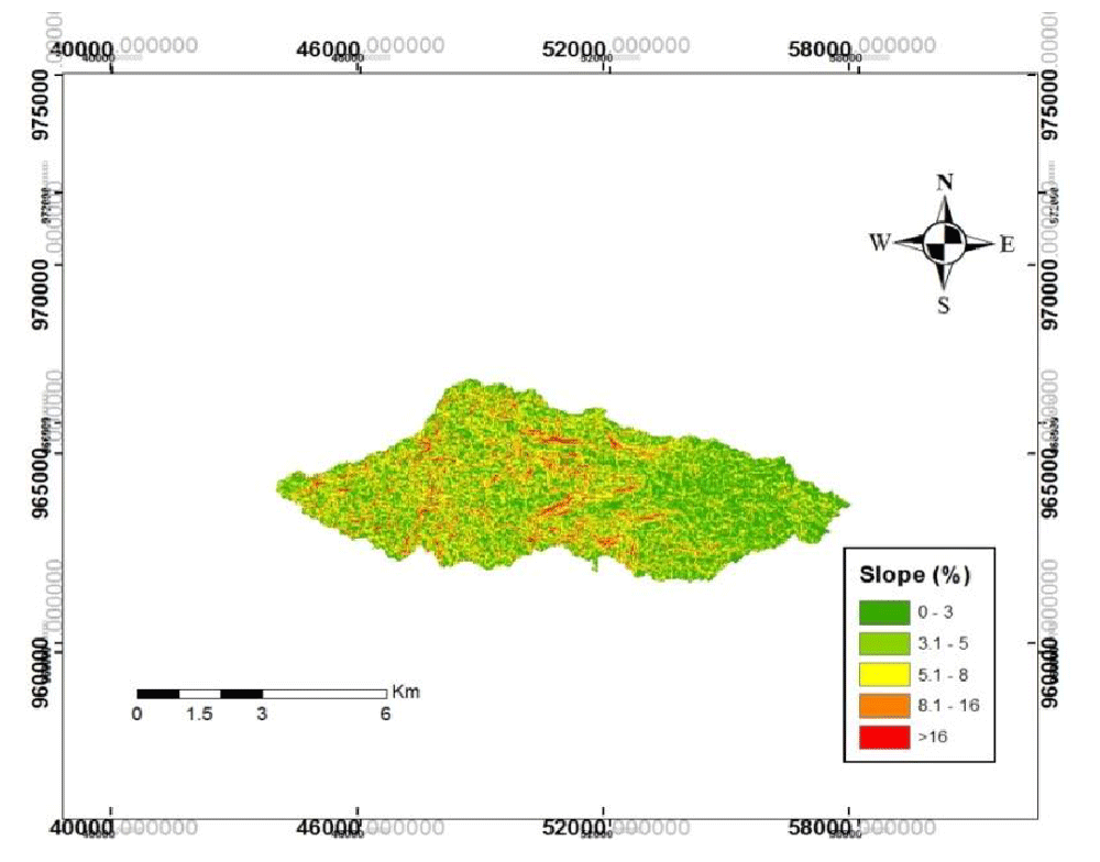
Characterizing slope of an area is important, which directly controls the balance between runoff response and soil infiltration rates of topography. Higher value of slope causes less infiltration of rainwater and high runoff water through top soil to recharge the groundwater [19]. The slope map of the study watershed was grouped in to five classes in percent for surface irrigation; flat or almost flat (0 – 3 %), gentle (3.1 - 5%), moderately steep (5.1 - 8%), steep (8.1-16%) and very steep (>16%) (Figure 6). After classified the whole watershed like that each land mapping unite (LMU) was grouped as flat (LMU-4), gentle (LMU-1&2,) and moderately steep (LMU-3) (Table 5). Consequently, most of the area of the watershed come under gentle(51.5%) and flat(27%) slopes, and can be classified as good category for surface irrigation [20].
Land suitability evaluation for surface irrigation
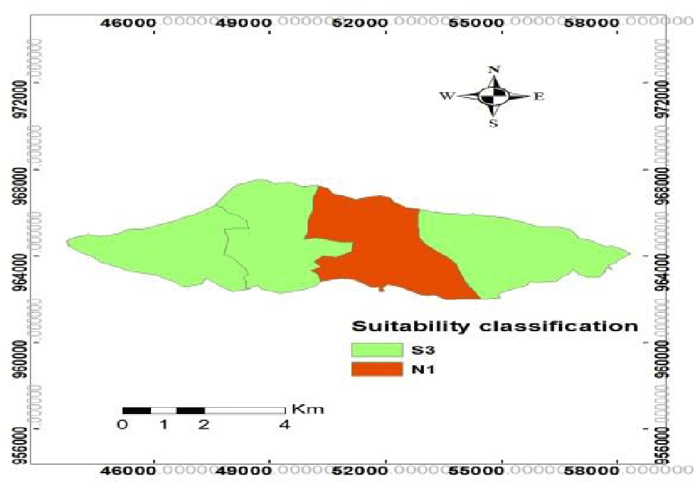
The capability index and its suitability class for surface irrigation of each land mapping unit(LMU) is presented in Table 6. The results showed that the LMU-1, 2 and 4, with a total area of 3064 ha (72.6%), were slightly suitable (S3) (Figure 7) for surface irrigation. The limiting factors were soil texture, slop and drainage. It was found that LMU-3, covering an area of 1154 ha (27.4%) was currently not suitable (N1) (Figure 6) for surface irrigation due to the high slop gradient. In addition, soil texture and soil drainage were other limiting factors in this LMU. Similar results were reported by Ibrahim, et al. [20]. For all LMUs, chemical soil parameters such as CaCO3, ECe, pH and the physical property (soil depth) were not limiting factors for surface irrigation in the study watershed. Similarly, Abraham, et al. [13] and Kassa, et al. [21] found that these parameters were not limited factors for surface irrigation in Northern Ethiopia.
Conclusion and Recommendations
Conclusion
Sound information on watershed characteristics such as soils, slop and other land characteristics provide a basis for decision making on proper utilization and management of natural resources. The importance of land evaluation points to opportunities for influencing future developments of land resources in the region using management techniques that are tailored to the characteristics of the landscape elements. The result of the study depicted that large portion (72.6%) of the study area was slightly suitable (S3) for surface irrigation purpose. The most important limiting factors in the area under study included land slope and physical properties of the soil, especially soil texture and soil drainage. While the soil chemical properties were highly suited for surface irrigation. Therefore, the area is potential for irrigation production with some limitations and under proper management it can benefit the local community to meet the food demand.
Recommendations
In order to sustainably develop the area for irrigation development, the following points should be considered:
- Land leveling operation or soil conservation work has to be incorporated to break surface slope and to make it suitable for surface irrigation.
- Due to shallow water table depth and fine textured soil of the study area has poor drainage and workability problems under excessive moisture regimes. These soils could be made more suitable by adopting improved drainage system, soil and crop management practices.
- In order to protect the flooding of lower catchment, watershed management activities including the construction of flood protection ditches is recommended.
We are very grateful to Dambi Dollo University for financial support. We also thank to the peasants and Agricultural experts in the study area.
- Abraham M, Azalu A (2013) Land Suitability Evaluation for Irrigation in Dejen District, Ethiopia. International Journal of Scientific and Research Publications 3. Link: https://bit.ly/3pd9Q4L
- Awulachew SB, Ayana M (2011) Performance of irrigation: An assessment at different scales in Ethiopia. Experimental Agriculture 47: 57-69. Link: https://bit.ly/3DRm8nB
- Awulachew SB, Erkossa T, Namara RE (2010) Irrigation potential in Ethiopia. Constraints and opportunities for enhancing the system, International water Management Institute contributions, Addis Ababa. Link: https://bit.ly/3vrEsk1
- Gebre G (2020) Impact of Small Scale Irrigation Development on Farmers’ Livelihood Improvement in Ethiopia: A Review. Journal of Resources Development and Management 62: 10-18. Link: https://bit.ly/30FYRqv
- Weldeabzgi GG (2021) Performance Evaluation of Organizational Arrangement in Irrigation Water Management at Serenta Irrigation Scheme, Northern Ethiopia. Irrigat Drainage Sys Eng 10 : 273. Link: https://bit.ly/3G1n76E
- Pan G, Pan J (2012) Research in crop land suitability analysis based on GIS. Computer Comput Technol Agric 365: 314-325. Link: https://bit.ly/3lR2stV
- Reddy O, Maji GE, Gajbhiye KS (2002) “GIS for morphometric analysis of drainage basins.” GIS India 11: 9-14.
- Dagnenet S (2013) Assessment of Irrigation Land Suitability and Development of Map for the Fogera Catchment Using GIS, South Gondar. Asian Journal of Agriculture and Rural Development 3: 7-17. Link: https://bit.ly/3pdYwp0
- Sys C, Vanranst E, Debvay J (1991) Land evaluation. Part: III. General Administration for Development Cooperation Agriculture, Brussels, Belgium 199.
- Biplab M, Gour D, Sujan S (2017) Land suitability assessment for potential surface irrigation of river catchment for irrigation development in Kansai watershed, Purulia, West Bengal, India. Sustain. Water Resour Manag. Link: https://bit.ly/3BW6tD0
- Narayana S, Inayathulla M, Thabrez M, Shashishankar A (2017) Land Suitability Evaluation of Soils for Crop Production. International Journal of Innovative Research in Science, Engineering and Technology 6. Link: https://bit.ly/3vmY2OB
- Gebre G, Tekalign K, Gezahegn G, Sime D (2021) GIS Based Morphometric Analysis of Gudina Wacho Watershed, Western Ethiopia: Suggestion for Surface Irrigation Development. Journal of Water Resources and Ocean Science 10: 92-99. Link: https://bit.ly/30J43dj
- KWZ (Kellem Wollega Zone Agricultural office) (2020) Annual report, unpublished.
- Williams DE (1949) A rapide manometric method for determination of calcium carbonate in soil. Soil Sci Am Proc 13: 127-129. Link: https://bit.ly/2ZaXMGB
- FAO (1985) Guidelines: Land Evaluation for Irrigated agriculture. FAO Soils Bulletin 55, Rome, Italy. Link: https://bit.ly/3FZNF8g
- Gee GW, Bauder JW (1986) Particle Size Analysis. Part 1. Physical and mineralogical methods, Madison, Wisconsin. USA 404-408. Link: https://bit.ly/3G0igm3
- Briza Y, Dileonardo F, Spisni A (2004) Land evaluation in the province of ben Slimane, Morocco. 21stCourse Professional Master, Remote Sensing and Natural Resources Evaluation 10 Nov 2000-22 June 2001-IAO. Florence, Italy.
- Abraham M, Daniel H, Abeba N, Tigabu D, Temesgen G, et al. (2015) GIS Based Land Suitability Evaluation for Main Irrigated Vegetables in Semaz Dam, Northern Ethiopia. Research Journal of Agriculture and Environmental Management 4: 158-163. Link: https://bit.ly/3DUL5yo
- Mohammad FR, Chowdhury SJ, Riad A, Quamrul HM (2017) Morphometric Analysis of Major Watersheds in Barind Tract, Bangladesh: A Remote Sensing and GIS-based Approach for Water Resource Management. Hydrology 8: 86-95. Link: https://bit.ly/3DZtKVj
- Ibrahim M, Ibrahim SI, Elhag MH, Dafalla MS (2015) Surface Irrigation SuitabilityAssessment of the Soils of Almanaqil Ridge, Gezira State, Sudan. International Journal of Emerging Trends in Science and Technology 2: 2803-2814. Link: https://bit.ly/3n9fEcS
- Kassa T, Van Rompaey A, Poesen J (2010) Land Suitability Assessment for Different Irrigation Methods in Korir Watershed, Northern Ethiopia. Journal of the Dry lands 3: 214-219. Link: https://bit.ly/3DZtt4J
Article Alerts
Subscribe to our articles alerts and stay tuned.
 This work is licensed under a Creative Commons Attribution 4.0 International License.


 Save to Mendeley
