International Journal of Agricultural Science and Food Technology
Crops pattern change and agricultural diversification: A case study of Domar Upazila, Nilphamari
Md. Naimur Rahman*
Cite this as
Rahman MN (2020) Crops pattern change and agricultural diversification: A case study of Domar Upazila, Nilphamari. Int J Agric Sc Food Technol 6(1): 022-029. DOI: 10.17352/2455-815X.000050Cropping pattern means the proportions of area under various crops at a point of time. This paper provides a comprehensive assessment of crop pattern, crop productivity using climate, water and crop yield models. The existing studies present that climate change models with higher spatial resolution can be a way forward for future projections. Various types of statistics, other secondary data and primary questionnaire method was applied to measure and analysis the problem. The cropping pattern differs from macro to micro region, both in space and time and is governed largely by the physical, cultural and technological factors. For the purpose of agricultural regionalization and planning, it is necessary to divide the area/ region into homogeneous region on some well-defined basis. Increased crop production could be expected if the irrigated areas expansion prevails. In addition, it will lead degradation of the environmental phenomenon. The different crop pattern of this region varies the diversification of several discussed strength including soil, erosion, flooding, waterlogging, precipitation, source of irrigation and others. The areal unit of crop ranking is the dominant variables for first, second and third ranking. The importance of adoption of suitable cropping patterns in a developing country cannot be over emphasized. The horizontal expansion of agriculture is not possible without heavy capital investments. If the encouraging method does not get proper result for two or multiple crop pattern for extended areas of land then the food security could be ensured by zonation of crop pattern or judicious regulation.
Introduction
Agriculture is one of the leading occupation in Bangladesh and it plays a vital role in shaping the economic condition of the farmers as well as the whole country. It contributes about 14.10 (2017-2018) percent of total GDP. Agriculture provides food to the masses, green fodder for livestock and supplies raw material to various agro-based industries. Hence, systematic, scientific, and proper cropping pattern and crop combinations are the most important aspect for better out-put in agriculture. Cropping pattern indicates the proportion of area under various crops at a point of time whereas the crop combination indicates to grow different types of crops under the same agriculture field. Both Cropping pattern and combinations area dynamic concept as it changes over space and time. Terrain, topography, slope, temperature, amount and reliability of rainfall, soil and availability of water for irrigation are some factors responsible for the cropping pattern and combination in any area.
Cropping pattern and combination are also the part of behavioral approach in geography, because it reflects the performance of the farmer for various crops sown in an agricultural field. Hence, by considering the facts related to better cropping pattern, the present research has been attempted to analyzing the irrigation facilities, cropping pattern, crop ranking and crop combination.
The pattern of cropping system could be demonstrated through soil agro-ecological measurement as well as climatic condition of a region [1].
Nevertheless, at farmers’ level, potential productivity and financial edges act as guiding principles whereas choosing a selected crop/cropping system. These selections with relevancy selection of crops and cropping systems square measure more narrowed down below influence of many different forces associated with infrastructure facilities, socio-economic factors and technological developments, all operative interactively at micro-level.
These are
Infrastructure facilities: Irrigation, transport, storage, trade and selling, post-harvest handling and process etc.
Socio-economic factors: monetary resource base, land possession, size and sort of land holding, social unit wants of food, fodder, fuel, fiber and finance, labour availableness etc.
Technological factors: Improved varieties, cultural necessities, mechanization, plant protection, access to data, etc [2].
Cropping pattern suggests that the proportions of space underneath numerous crops at some extent of your time. The crop statistics are accustomed denote cropping pattern. The cropping pattern differs from macro to small region, each in area and time and is ruled mostly by the physical, cultural and technological factors. For the aim of agricultural regionalization and coming up with, it’s necessary to divide the area/ region into consistent region on some well-defined basis.
Cropping pattern implies the extents of region under different yields at a point of time. The yield measurements are utilized to signify trimming pattern [3]. The cropping pattern varies from full scale to small scale locale, both in reality and is represented generally by the physical, social and mechanical components. With the end goal of farming regionalization and arranging, it is important to isolate the region/district into homogeneous locale on some well-characterized premise.
There can be various physical, climatological and agronomic criteria on which editing example can be made. It might differ from area to locale contingent upon the landscape, geology, slant, temperature, sum and unwavering quality of precipitation, soils and accessibility of water for water system. The recognition and evaluation of setting conjointly manual for develop bound harvests during a locale. The cropping pattern examples of a segment or locale unit could likewise be resolved on the possibility of area quality of individual harvest.
The perception and assessment of environment also guide to grow certain crops in a region. The cropping patterns of a region or areal unit may be determined on the basis of areal strength of individual crop.
Objectives
The major objectives of the study are:
a. To assess and mapping of the cropping pattern
b. To assess the crop ranking
c. To study the crop combination
Literature review
Mondal [4], Crop agriculture in East Pakistan is unnatural once a year by the challenges, like a) Loss of arable land, b) Increment, c) Climate Changes, d) Inadequate Management Practices, e) Unfair value of Produces, and f) Lean Investment in analysis. In East Pakistan, about 80,000 hour angle of cultivable land are going out of production once a year. The loss is awful and desires to be addressed instantly. The land use policy of the government ought to be updated and enforced instantly to prevent any loss of cultivable land. Another drawback to agriculture is that the increase within the growth of population. The dual drawback of cultivable land loss and increment have to be addressed at the same time to confirm property crop production. Country’s crop production is additionally affected oftentimes by drought, and temperature change. Varieties/technologies tolerant to those natural hazards got to be developed. Renewable energy, reduction within the use of fossil fuels, and conversion are suggested to mitigate the adverse effects of temperature change. To sustain crop production, chemical fertilizers should be integrated with organic manure and expensive non-urea fertilizers ought to still be sponsored. Incidence of pests and diseases has of late become severe because of temperature change impacts. Therefore, a lot of varieties immune to the pests ought to be evolved. Tiny and marginal farmers of East Pakistan has restricted access to institutional credit. They’re not eligible for Microcredit of NGOs either. Institution of a replacement institution/foundation in line with PKSF is suggested to fulfill their desires. These farmers don’t have farmers’ associations or cooperatives to bargain for truthful price of their produces. Government would possibly encourage institution of farmers’ cooperatives to confirm truthful value of their produces. To form such cooperatives eminent, top-down approach by the influential should be avoided. Investment in agricultural analysis ought also be raised to a minimum of a pair of gross domestic product to assist generate technologies to deal with Drought hazards and bare such technologies at farmer’s level.
According to UNEP [5], This study was conducted with 718 farmers of owner, owner-cum-tenant and tenant farmers of irrigated and non-irrigated villages at fourteen Upazila (sub-district) in 2 severe drought-prone districts of northwestern East Pakistan through a semi-structured form. It assessed farmer’s perception and awareness, impacts and adaptation measures of farmers towards drought. The results discovered that farmers in each areas perceived a modified climate in recent years. They not solely known that drought is the most prevailing disaster within the study space owing to downfall and temperature variation, however conjointly groundwater depletion, lack of canal and watercourse dragging, accumulated population, deforestation, etc. accelerate drought during this space. As a consequence of drought, agriculture yet as farmer’s social life and health are vulnerable the foremost. To deal with drought, farmers are adapting numerous practices chiefly through science management, crop intensification, water resource exploitation, etc. Among totally different farmer teams in each irrigated and non-irrigated areas, it’s been seen that owner farmers have additional capability to adopt new technology than owner-cum-tenant and husbandman. Finally, this study suggested that interrelation among totally different stakeholders, effective early warning system and improved conservation systems are essential to sustain farmers sustenance within the event of drought.
Islam, Rahman [6], assessed the diversification changing pattern between 1980/81 and 2002/03 and found diversification in regions over different crops prevails.
Rahman [7], studied agricultural growth strategy for crop diversification in Bangladesh. Author used stochastic input-distance function to measure economic efficiencies and diversification on farm level and found that the development of rural infrastructure is necessary for the technical development of crop diversification. It also showed the economic scale existence which has essential effect on crop diversification and combination.
Sarker et al., [8]. Showed four cropping pattern in northwestern part of Bangladesh including Wheat, Aman rice and non-wheat pattern. The study reveled that wheat, potato, Aman rice production is higher whereas wheat-T. Aus Rice-T. Aman production is lower equivalent wheat yield for the entire four year.
The cropping in the coastal area is different from the study area. Because in the coastal area cropping pattern is rice/shrimp and rice/non-rice cropping. Furthermore significant increased of salinity impacting adversely in the coastal cropping system of Bangladesh which is leading the reduction of profit through cropping over 12-15 years [9].
Miah [10], found the pattern of crop diversification which indicates Boro, Aman as well as Aus is the major crop and the diversification of cropping is an essential phenomenon throughout the country.
Rahman, Kazal [11], tried to find the factors which is playing major role for the diversification over 17 regions of Bangladesh in between 1990-2008 of a 19 year period. They showed that considerable declination of the diversity of crops including, minor cereals, oilseeds, jute, pulses sugarcane and increased amount of major crops pattern including rice and vegetables. This observation is probable similar to the study of Domar upazilla that major cropping prevails in a great extent.
In India agriculture is a key element for its economy where more than half of the rural people depended on it of about 67 percent of marginal people. For climbing up economically the farmers are using the techniques of diversified cropping pattern which also led increased amount of non-food crops instead of food crops [12].
Thapa et al., [13], indicated the impact of crop diversification on the measurement of household welfare regarding high-value crops (HVCs) based on the production assessment. In addition HVCs has better impact on the reduction of poverty and significant increase of per capita income. This study also recommended 35 percent of least derive for the revenue so that it will assist to decline poverty considerably.
Gamar et al., [14], in their study shown that less sutibality of crop production in dry land instead of high rainfall prevailing area. It also showed that women farmers need special consideration to continue farming activities and reveled major crops as sorghum, pearl millet, sesame, ground nut, hibiscus, cow pea, okra, water melon, snake cucumber in their study area of Sheikan and Elrahad of North Kordofan in Sudan.
Mondal [4], assessed that in Bangladesh every year utilization of arable land taking place of about 80000 hector. There are mainly two problem arising growth of population is causing the production of agriculture in a less amount. In addition for the sustainability of agricultural production chemical fertilizer must be replaced by organic manure and renewable energy is also recommended for the use of technology of agricultural land optimization and production.
KalpanaSastry R [15], introduces nanotechnology by which a framework could create food security. Productivity of agriculture, soil texture, soil fertility, water availability, and quality of food in storage and ordination are indicated as the elementary determinants of food security that can be influenced by improvements in nanotechnology. The framework is improved and developed in two stages: (i) mapping nanotechnology to agri-food thematic areas across the agricultural value chain and (ii) from the thematic areas to the food security determinants. The model allows identification and prioritization of efficient areas for nanotechnology implications to increase food security. It could be compared with green revolution technologies and agricultural biotechnology which will lead the greater and faster influence on all the elements of the agri-value chain with concomitant social, moral, legal and environmental significances. In addition it is essential phenomenon that investment is needed for the improvement of an agri-nanotechnology and for assessment of its implications for society.
Manoj P [16], in his paper discusses the influence of trade liberalization on growth, poverty, and food security in India with the help of a national level Computable General Equilibrium (CGE) model. It indicates that GDP enhancement and earning penury shortening that strengths happen following trade liberalization need not essentially outcome in development in the food security nutritional capacity of the miserable. Record from simulations of (partial) trade reforms indicating a possible Doha-like status show that the bottom 30% of the population in both urban and rural areas tolerates a reduction in calorie and protein intake, in contrast to the rest of the population, even as all households increase their intake of fats. Several outcomes show that trade policy analysis has essential identifications of food security as well as overall growth and poverty traditionally considered in such studies.
Study area
Domar Upazila (Nilphamari district) placed in between 26°02’ and 26°19’ north latitudes and in between 88°46’ and 88°54’ east longitudes. It’s finite by province of Asian country on the north, Nilphamari Sadar Upazila on the south, Dimla and Jaldhaka Upazilas on the east, Debiganj Upazila on the west. Water bodies of Doamr upazila consists Jamuneshwari, Buri Tista and Deonai Table 1, Figure 1.
Methodology and method
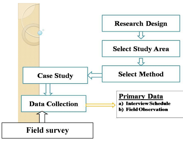
Survey and Case study method was taken to conduct this study. The main purpose the study was to explore the agricultural impact or the rural community due to drought from the selected area. Primary data was used in conducting this study. To collect primary data 4 case studies were conducted with 100 questionnaire survey among the selected area. The whole study design was following maps way Figure 2.
Data collection techniques and tools
Data were collected for this project paper was from 100 respondent in Domar in Nilphamari district. For this project paper structured questionnaire was used. Some of data were collected from agriculture extension office in domar upozila.
Data collection
Data were collected in March to June 2019. My friends are helped to collected data because they knew the location very well. All collection received three days on questionnaire. To conduct the survey a semi structured and self-employed questionnaire has been used containing pertinent question in relation to the objectives of the study area.
Household survey
Household survey was conducted to gather more information about the crops pattern and agricultural diversification. Various information regarding to the crops pattern and agricultural diversification from structured questionnaire.
Observation
Participatory, Non- Participatory observation was applied during research to study the location, and concerning crop pattern. Interview with key informants. Some knowledgeable person such as elderly persons, teachers were selected as key information’s to carryout research.. Guideline were prepared for key informants interview.
Survey tools
A semi-structured survey was conducted to collected necessary primary data from the target population. For conducting survey, a semi-structured questionnaire was used data were collected using two questionnaire developed for this study: One is farmer, and another is agricultural officer. Each questionnaire is designed for the interviewer-completed interview. The average time took to complete the worker questionnaire was 20 minutes and owner /officer was about 10 minutes and 15 minutes, respectively.
Data collection methods
To prepare the report data were collected by different methods. These methods can be divided in two categories.
Primary data collection methods: Primary mainly indicates the raw data which is obtained from variety of sources. The methodology used for collecting primary data are given below-
➢ Questionnaire: Conducted an open ended questionnaire.
➢ Interview: Individual direct contact(face to face) was applied for interview
➢ Observation: Carefully observed all phenomenon’s.
Secondary data collection methods: The data which have been collected before by some agencies are called secondary data. The methodology used for collecting secondary data are given below-
➢ Internet
➢ Atlas
➢ Related books
➢ Journals
➢ Different organization
Data representation methods
The methods by which data have been presented on this report is data presentation methods. These methods is-
• By Numeric Data
• By Maps
These are the methodologies which have been used to form this study.
Results and discussion
Crop pattern
The crops of the watershed area are divided into two main categories viz. Kharif and Rabi. The former one is the summer season harvest and the latter is the winter season harvest.
Crop of kharif season
Kharif is a very important cropping season during June to October. It occupies more than Rabi cropped area in the watershed. Paddy and Sugarcane are very common crops of this season.
Crop of rabi season
The Rabi crops are cultivated with the advent of the winter season, generally from the end of October to beginning of November. The main Rabi crops are Wheat, Gram, Barley, Pulses and the commercial crops are Groundnut, Oilseeds, and Cotton. In the study area, only Wheat is predominated Rabi crop on whole agriculture land.
Description of agricultural land
The crop pattern must be improved in other specific areas because 61.36 percent (Table 2) two crop and 33.04 percent (Table 2) three crop is the major crop production patterns which is not in optimum level. Furthermore, due to the rapid growth of population two cropping land must be considered for three crop land and that could create a balance system of crop function.
Farmers family
The family of the farmers is in very poor condition. Because below table indicates the family perspective of small, marginal and land-less farmers are more than 75 percent which is a dominating character. These depended families on agricultural activities must be introduced a wealthy pattern of crop so that they can improve their present status Table 3.
Land type
The land type is leading the opportunity for enlarging the agricultural activities in the context of high land 12590 hector and medium high land 8730 hector. Nevertheless, medium low land of 3765 hector has also a moderate efficiency for the agricultural formation Table 4.
Crop ranking
The study of agriculture region is of great importance in geographical studies. The regional dominance of various crops can be determined by comparing the relatively a real strength of various crops. This can be obtained by ranking them, for each paragon, according to the percentage of the total harvested cropland occupied by each crop.
Year wise agriculture production
Table 5 is the illustration of the different crop production on the basis of various year. The considerable change could be identified on the session 2018-2019 which is defining every major crop production is increased except wheat production is declining from 2014 to 2019. If proper nurturing and method applied to the land for example which is already mentioned that possibilities of two crop production transforms into three crop production continues then the growth of cropping will take form broader. In addition, subsidy and land fertile must be increased so that wheat production could be increased.
Union wise agricultural production
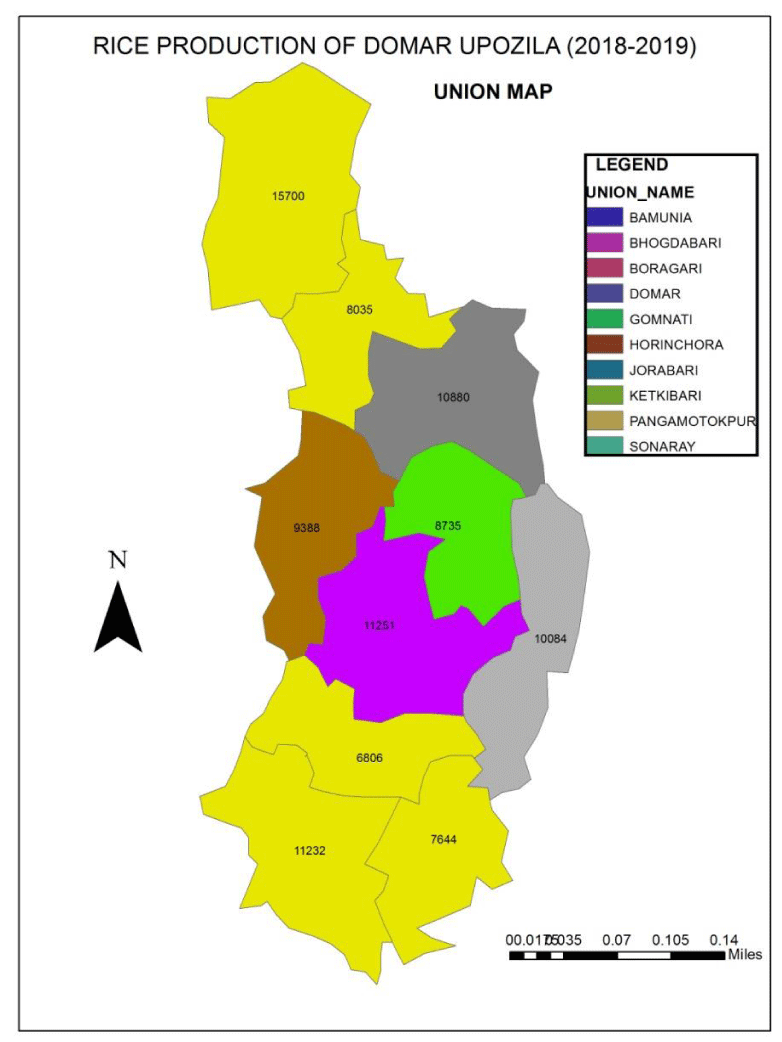
On the basis of area and production calculation Gomnati, Bamunia and Horinchora produces greater amount of rice than other union of 3.2 percent and the lowers production is measured for Jorabari union of 0.32 percent.
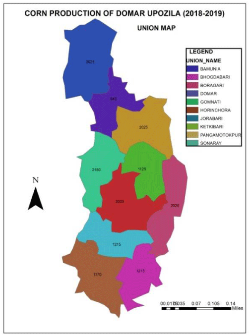
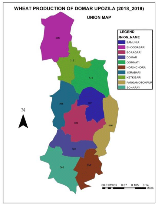
On the other hand, wheat production is very less comparing with other crop production. In addition, the percentage of production remains same of 3.3 except Ketkibari and Gomnati 2.29 and 3.08 percent respectively. But it is surprising that in every area corn production prevails same of 9 percent. Furthermore, potato production takes forms into 21 percent for all the union instead of Bamunia 20.58 percent and Pouroshova 12 percent. Mustard production is in the top position for lesser productivity (Table 6) in a lesser area which is ahead of wheat production in the following unions.
Nevertheless, for mustard and wheat production cost management is very expensive and it causes the land less fertile as well as the demand of market is not suitable for these product of the respected area.
The crop ranking is also measured on the basis of three elements i.e
A. Percentage of net sown area,
B. Percentage of total production,
C. Average yield per hectare.
It is observed that the Rice crop has first ranked whereas the Potato got second ranked due to high yield. The crop got third position is corn. The crops wheat and mustard lied at fourth and fifth rank respectively. The yield of various crops affects the ranking of this section as compared to the previous.
The provided figure illustrates the different amount of produced crop. The first, third and fourth ranked crop production is shown on these following maps Figures 3-5.
Conclusion
Cropping pattern study constitutes a crucial facet of agricultural geographic’s for the regionalization of agricultural diversification on the basis of an essential phenomenon The crops area unit typically full-grown in combos and it’s seldom that a selected crop occupies a foothold of total isolation alternative crops in a very given space at a given period. The indices of cropping pattern, crop ranking and crop combination indicate the complexities of crop distribution in quantitative manner. About 52 percent of total area of the cultivation with a wide variety of Kharif and Rubi crops like Rice, Paddy, Wheat, Corn, Mustard and more. The crop Rice is the first ranking crop and Potato comes at second and third place corn respectively. The study also found that 61.36 percent land production for two crop and 33.04 percent is for three crop pattern. The form of the areas of crops could be verified through physical factors whereas the extent of crops could be diversified on the basis of socioeconomic condition. The pattern of crops and crop combination are mostly controlled by topography, soil and irrigation facilities. The spatial variations of cropping pattern identified in the basin area are highly useful not only for watershed development planning but also for the economic development of the farmers lives in basin area. The study of crop combination is additionally useful for the study of the great space development coming up with notably for the agricultural areas. The importance of adoption of appropriate cropping patterns in a very developing country like Bangladesh can not be overemphasized. The horizontal growth of agriculture isn’t attainable while not serious capital investments. Solely even handed utilization of land by adopting a lot of remunerative cropping patterns, scientific rotation of crops and multiple cropping might facilitate in overcoming the food and material issues of the country.
Recommendation
➢ Agriculture ought to be treated as a priority sector.
➢ Tiny and marginal farmers ought to be recognized as a special cluster. Because majority of rural individual are depended on it as well as it has a great influence on GDP of Bangladesh [17,18].
➢ The status of education standing of the individuals is incredibly low. It must be treated as a major concern and should be addressed properly. It’s the route reason behind low swaraj among the individuals of the study Area.
➢ The individuals must be inspired regarding various cropping pattern
➢ Technical information ought to be give the individuals.
➢ To measure and retain the optimum land configuration must be taken as a egregious responsibility by the government.
➢ All the relevant policies like water policy, live stock policy, land use policy ought to be support to each other and a combinational framework could be done in this perspective.
➢ The practice of crop insurance must be recognized broadly.
➢ Government ought to increase investment in tiny and medium irrigation
➢ Government ought to promote rain water gathering and surface water utilization using the local water bodies of the study are.
➢ Cropping pattern should be joined with native essentialities and market pattern.
This work was financially supported by the Fundamental Research Funds for the Central Universities (KYZ201745). We are also grateful to the Priority Academic Program Development of Jiangsu Higher Education Institutions (PAPD) and Jiangsu Provincial Double-Creative Doctorate Plan.
- Husain M (1996) Systematic Agricultural Geography. Repented 2004, Rawat Publication,Jaipur and new Delhi 217. Link: https://bit.ly/2Q5VfpA
- Das P (2004) Cropping Pattern (Agricultural and Horticultural) in Different Zones, their Average Yields in Comparison to National Average/ Critical Gaps/Reasons Identified and Yield Potential. Status of Arm Mechanization in India 3: 3-4.
- Murugesan J, Gangai P, Selvam K (2018) Patterns of Crop Concentration, Crop Diversification and Crop Combination in Tiruchirappalli district, Tamil Nadu. IJIRST 4. Link: https://bit.ly/3cNTFSZ
- Mondal M (2010) Crop Agriculture of Bangladesh: Challenges and Opportunities. Bangladesh Journal of Agricultural Research 35: 235-245. Link: https://bit.ly/2W4Carp
- UNEP (2009) Vulnerability and Impact Assessments for Adaptation to Climate Change (VIA Module). IEA Training Manual 2. Link: https://bit.ly/2TZJ66y
- Islam N, Rahman PMM (2012) An assessment of crop diversification in Bangladesh: a spatial analysis. Appl Econ Lett 19: 29-33. Link: https://bit.ly/39HsuHw
- Rahman S (2009) Whether crop diversification is a desired strategy for agricultural growth in Bangladesh? Food Policy 34: 340-349. Link: https://bit.ly/2TOmQfO
- Sarker MAZ, Alam MA, Hossain A, Mannaf MA (2014) Agro-Economic Performance of Crop Diversification in Rice Based Cropping Systems of Northwest Bangladesh. Agriculture Forestry Fisheries 3: 264-270. Link: https://bit.ly/3cPKJMY
- Kabir MJ, Cramb R, Alauddin M, Roth C (2015) Farming adaptation to environmental change in coastal Bangladesh: shrimp culture versus crop diversification. Environment Development and Sustainability 18: 1195–1216. Link: https://bit.ly/39He8a8
- Miah MA (2011) Crop diversification in Bangladesh: Past initiatives and future research and policy needs. CAPSA Palawija Newsletter 28: 6-8. Link: https://bit.ly/2IOEgEl
- Rahman S, Kazal MH (2015) Determinants of crop diversity in the regions of Bangladesh (1990-2008). Singapore Journal of Tropical Geography 36: 83-97. Link: https://bit.ly/2W2UL7e
- Ansari AN (2018) An Analysis of Crop Diversification in India. World Wide Journal of Multidisciplinary Research and Development 4: 274-280. Link: https://bit.ly/2TTHJGF
- Thapa G, Kumar A, Roy D, Joshi PK (2017) Impact of Crop Diversification on Rural Poverty in Nepal. Canadian Journal of Agricultural Economics 66:379-413. Link: https://bit.ly/2W8V5Sh
- Gamar Y, Omer A, Hatim G, Tarig E, Abdelatif A, et al. (2016) Identification of Field crop structure and production constrains with special consideration of gender aspect of resource poor farmers in north Kordofan state of Sudan. Journal of Agricultural Extension and Rural Development 8: 19-28. Link: https://bit.ly/2vKDG7D
- KalpanaSastry R, Rashmi HB, Rao NH (2010) Nanotechnology for enhancing food security in India. Food Policy 36: 391-400. Link: https://bit.ly/3aILHss
- Manoj P, Ganesh-Kumar A (2008) Trade Liberalization, Poverty and Food Security in India. Indira Gandhi Institute of Development Research WP-013. Link: https://bit.ly/336EboN
- Rahman MN (2019) Urban Expansion Analysis and Land Use Changes in Rangpur City Corporation Area, Bangladesh, Using Remote Sensing (RS) and Geographic Information System (GIS) Techniques. Int J Adv Study Res Work 2. Link: https://bit.ly/336jyZI
- Bangladesh Population Census (2001) Bangladesh Bureau of Statistics; Cultural survey report of Domar Upazila 2007
Article Alerts
Subscribe to our articles alerts and stay tuned.
 This work is licensed under a Creative Commons Attribution 4.0 International License.

 Save to Mendeley
