Annals of Environmental Science and Toxicology
Modeling the groundwater level for an arid aquifer under different groundwater management scenarios
Karim Soliman*
Cite this as
Soliman K (2022) Modeling the groundwater level for an arid aquifer under different groundwater management scenarios. Ann Environ Sci Toxicol 6(1): 087-096. DOI: 10.17352/aest.000059Copyright
© 2022 Soliman K. This is an open-access article distributed under the terms of the Creative Commons Attribution License, which permits unrestricted use, distribution, and reproduction in any medium, provided the original author and source are credited.Groundwater is considered the only source of water in arid climate regions. Additionally, population growth is stressing the groundwater resources in the study area, especially in these regions leading to excess groundwater exploitation to meet the demands (domestic, and agricultural). Thus, the groundwater level may decline in the future causing a water scarcity problem. In order to overcome this problem, it is worth necessary to perform mitigation measures prior to raising the groundwater level by augmenting the groundwater in the hydrogeological system. Mitigation measures might be reducing the abstraction rate and installing new artificial recharge sites. To assess the potential of these measures, numerical modeling can be applied. Gaza strip aquifer was chosen as a case study due to the following reasons: arid aquifer, significantly stressed due to over-exploitation of groundwater. Different researchers have already proposed different management scenarios considering these mitigation measures, but most of them considered unreliable management scenarios to predict future groundwater. Some of them reduced the abstraction rate which will lead to the loss of agricultural lands. Whereas, the others increased the artificial recharge rate which is unfeasible to implement in the study area for the next 20 years. Hence, we applied numerical modeling in this article to predict the future groundwater level based on these mitigation measures taking into account reliable management scenarios according to the study area’s current situation . The results indicate that combining both reducing the abstraction rate and increasing the artificial recharge is so promising and they were compared with the latter obtained by the previous researchers.
Introduction
Water scarcity is the main issue in the Middle East particularly in the Gaza strip because it is situated in a semi-arid environment and over-populated area. Water scarcity affects socioeconomic growth and sustainable development. Therefore, assessing the main water resources plays a major role to secure water for the future generation via future sustainable development plans.
The conventional water sources are limited in the Gaza strip, where the main water source is groundwater stored in the Gaza strip aquifer. The Gaza strip aquifer is a coastal aquifer that is affected by seawater intrusion. Additionally, the aquifer is stressed due to groundwater over-exploitation, as the water supply doesn’t match the water demand for agricultural (around 70%) and domestic activities [1].
The over-exploitation affects the groundwater level, where the groundwater level has been severely depleted in the last decades. According to Hamdan, et al. [2], a deficit of 50 Mm3 occurs annually leading to groundwater depletion and deterioration. Low groundwater levels may increase the saline water flux intruding from the sea to the aquifer. Additionally, the aquifer is contaminated due to unmanaged irrigation, land use, and solid waste effluent causing groundwater deterioration. Therefore, it is worth required that management plans should be accomplished to increase the groundwater levels prior to preventing the seawater intrusion phenomena and replenishing the aquifer to restore the groundwater quality.
Different researchers have introduced different management strategies to increase the groundwater level owing to restore the groundwater quality. Dentoni, et al. [3] assessed the different seawater intrusion strategies by modeling the aquifer followed by optimizing the pumping rates such that the groundwater heads increases by 4.5% and decrease the seawater intrusion effects by 5%. Melloul & Collin [4] concluded that high-priority management activities should be implemented to reduce pollution contamination. It is recommended that mitigation measures must be accomplished by injecting water using wells and recharge basins via non-conventional resources such as desalination and Tertiary Sewage Effluent (TSE).
Al-yaqubi [5] introduced the Palestinian Water Resources Policy which considered the principal objectives for sustainable water resources management: providing quantity and quality of water for domestic purposes according to WHO standards, supplying water required for agricultural production, managing the Gaza coastal aquifer via preventing groundwater deterioration. Most researchers considered different approaches to augment the groundwater resources in the study area. To achieve that, wastewater might be reclaimed, seawater could be desalinated, and new water sources (including non-conventional sources) should be introduced to meet the demands and augment the groundwater resources by reducing the pumping rate.
Qahman & Larabi [6] introduced 2 pumping schemes to predict future changes in groundwater levels and they concluded that the aquifer has to be replenished by installing artificial recharge which may limit seawater intrusion and reduce groundwater depletion. Selmi [7] studied groundwater management under different scenarios including reducing the abstraction rate, and increasing the recharge. She recommended that using treated wastewater might increase the groundwater level at an affordable cost, whereas the latter water sources are unpractical and expensive.
Rahman, et al. [8] selected the best locations to install the artificial recharge sites using multi-criteria decision analysis and groundwater numerical modeling for the northern part of the aquifer. They concluded that the location of the infiltration ponds could be installed near the North Gaza Wastewater Treatment Plant. Additionally, they concluded that 50% of the study area is suitable for installing artificial recharge sites.
Abualtayef, et al. [9] suggested four management scenarios for the groundwater level. The first scenario is considered the base scenario where no change in abstraction rate or recharge rate occurs. The second scenario is to investigate the Palestinian Water Authority (PWA) stormwater plan. The third scenario includes the proposed Gaza Emergency Technical Assistance program, and the fourth scenario includes the combination of both the second and the third scenario. The results show that the fourth scenario shows the best enhancement of increasing the groundwater level from -15 m to 4 m above the Mean Sea level from the year 2020 to the year 2040.
Ibraheem & Saleh [10] modeled the hydrogeological system by reducing the abstraction rate by 50% to eliminate the saltwater intrusion problem. Also, he recommended that injecting wells along the coast could reduce the salt intrusion phenomena in the aquifer. Finally, a cost-benefit analysis should be conducted to check the feasibility of groundwater management in the study area taking into consideration the social and political issues.
Melloul & Collin [4] found that stringent measures should be conducted to secure water resources for domestic purposes. The measures include injecting water using wells via fresh non-conventional water resources such as desalinated sea, and brackish water, and importing freshwater from abroad. Additionally, the pumping rate should be managed such that the pumping doesn’t cause the up-coning of the saline layers from below. Seyam, et al. [11] investigated the influence of excess pumping on groundwater salinity using three different pumping scenarios. The first scenario includes no change in the current abstraction rate, the second scenario is to reduce the abstraction rate, whereas in the third scenario the abstraction rate vanishes.
Qahman, et al. [12] introduced optimization management scenarios for the abstraction rates. The results show that the optimum abstraction rate should vary from 26% to 34% of the total natural replenishment. However, the results are unfeasible because the demand is currently very high (more than 100% of the natural recharge rate). Weinthal, et al. [13] proved that increasing the abstraction rate along the border of the strip followed by reducing the abstraction rate within the study area would improve the quality of the groundwater. Additionally, injecting desalinated seawater extracted from the aquifer could remedy the aquifer.
Abd-Elhamid, et al. [14] simulated the seawater intrusion into the aquifer using numerical modeling incorporating different effects: climate change, sea level rise, and over-exploitation. It is found that all the factors will result in groundwater deterioration in terms of seawater intrusion into the aquifer. Redistribution of the pumping fields and change in agricultural practices could be a solution to mitigate seawater intrusion. Abu Al Naeem, et al. [15] conducted an integral approach of statistical, geostatistical, hydrogeological, and hydrogeochemical techniques to understand the factors affecting the groundwater. The main reason for salinization is groundwater over-exploitation. The geostatistical method demonstrates that the aquifer hydraulic properties (hydraulic conductivity) aids the seawater intrusion as the hydraulic conductivity is relatively high in the study area.
From the aforementioned literature, it has been agreed that the best groundwater management scenarios are to reduce the abstraction rate and inject freshwater into the hydrogeological system. However , most of the studies didn’t take into account the feasibility of reducing the abstraction rate and injecting the water into the system at a reasonable rate in the study area. In other words, no certain predicted groundwater levels are simulated by the previous studies considering reliable groundwater management scenarios according to the study area’s current situation. Thus, we tried in this article to find a certain future prediction for the groundwater level taking into consideration reliable groundwater management scenarios. To achieve this objective, a numerical groundwater flow model was applied to predict the groundwater level under different reliable management scenarios.
Materials and methods
Study area description
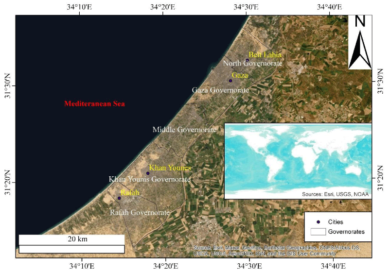
General description: Gaza strip is a coastal area located along the Mediterranean Sea shore with an area of 365 km2 [16]. It is situated between a latitude of 31o26’ and a longitude of 31o22’ (Figure 1). Around 1.94 million inhabitants are living in the strip in the year 2017 [2]. The climate is considered semi-arid where the annual precipitation rate ranges from around 140 mm to 425 mm [17], whereas the average temperature ranges from 13 degree Celsius in winter to around 25 degrees Celsius in summer [9].
Geology: Geology is studied by different researchers: Picard [18], Bartov & Arkin [19], Frechen, et al. [20], Al-Agha, et al. [21], and Galili, et al. [22]. Gaza strip is a coastal plain that is gradually sloping towards the coast of the Mediterranean Sea. The geological age starts from the Mesozoic to the quaternary geological formations. 2 formations are present in the aquifer: tertiary formation (Saqiya formation) and quaternary alluvial deposits (Kurkar group).
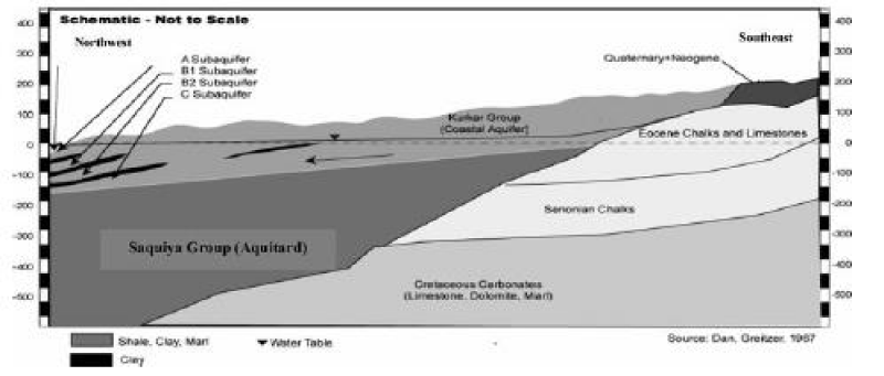
The coastal aquifer consists of the sand dunes and the kurkar group. The Kurkar group consists of sand dunes, which are formed during the marine and Aeolian depositional environments. Unconformity phenomena took place where this layer is placed above the Eocene chalks and limestone. The thickness of the Kurkar group ranges from 70 m in the east to around 200 m in the west [7].
The quaternary layer constitutes intercalated clay deposits and is randomly distributed in the area. The quaternary layers are hydraulically connected and can be represented as one aquifer. Figure 2 shows the hydrogeological cross-section of the aquifer.
Aquifer hydrogeology: Different pumping tests were carried out by Qahman, et al. [12] in different areas of the Gaza strip. The results show that transmissivity values range from 700 to around 5000 m2/d. On the other hand, the hydraulic conductivity ranges from around 20 m/d to 80 m/d where the porous media is considered a medium sand. The estimated effective porosity is around 0,25 and the specific yield varies from 0.15 to 0.3 and the specific storativity is around 0.0001 [12].
Dentoni, et al. [3] conducted a field campaign to determine the hydraulic parameters for the Gaza coastal aquifer. The hydraulic conductivity for the aquifer layers ranges from around 0.00023 m/s to 0.00093 m/s. However, the hydraulic conductivity for the aquitard is around 0.00000012. The porosity of the sand is around 0.35 and of the clay is 0.4. The specific storage is around 0.0001.
Groundwater recharge and discharge: Groundwater recharge is highly uncertain because it is spatially variable, especially in arid environments and it depends on the different climate and anthropogenic factors. Different researchers estimated the groundwater using different methods including estimating the recharge coefficient, water level fluctuations, chloride mass balance, land-use, and soil infiltration, numerical modeling (groundwater, water balance model), and soil moisture balance. It is found that the groundwater recharge ranges from around 24.5 Mm3 to 64 Mm3. However, Mushtaha, et al. [16] calculated the mean annual recharge rate precisely, as they used spatial daily rainfall and evapotranspiration from the year 1973 till 2016 to predict the recharge in the whole area. He found that the long-term mean annual recharge rate is around 24.5 Mm3.
However, the aquifer is not only recharged by rainfall but also by agricultural drainage, leakage from water and wastewater system, and recharge basins located all over the Gaza strip. Additionally, the lateral flow enters the Gaza strip from the South and ranges from 10 Mm3/yr to 15 Mm3/yr [5]. The total annual recharge rate ranges from nearly 56.5 Mm3 to 62 Mm3 [5]. It is worth noting that the groundwater recharge is low in the south causing a decline in the groundwater level.
Regarding the groundwater abstraction rate, 4000 wells are located in the Gaza strip, which is privately owned and used usually for agricultural purposes. Table 1 shows the estimated groundwater abstraction from the Gaza aquifer.
Groundwater flow model
General description: MODFLOW is a 3D finite-difference numerical model developed by MacDonald & Harbaugh [23] to simulate the groundwater flow in the quasi-steady and transient state in the porous media. The form of governing equation used for solving the groundwater flow problem in the MODFLOW model is mentioned in the following equation as described by Hamraz, et al. [24]. This equation is a combination of Darcy’s law and the law of conservation of mass Hamraz, et al. [24].
Where Kxx, Kyy, and Kzz are hydraulic conductivity in the directions of x, y, and z coordinate orthogonal axes respectively (parallel to the major axes of hydraulic conductivity) (L/T), h is the potentiometric head (L), R is the volumetric flux (represents source and sink) (L/T), Ss is the specific storage (1/L), and t is time (T)? This equation can determine the groundwater table and groundwater flux in the quasi-steady and transient state.
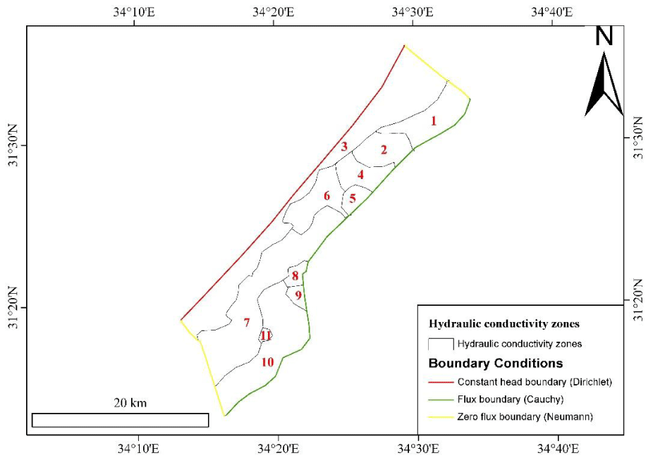
Conceptual model: To build a conceptual model, the boundary conditions were identified according to the study area. Since the study area is bounded by the Mediterranean Sea in the North, thus the northern boundary was assigned as a constant head boundary, where the head is equivalent to the mean sea level (0 m). The western and eastern border of the aquifer is assigned as a no-flow boundary (zero flux Neumann boundary) because the boundaries are nearly perpendicular to the equipotential lines (groundwater head) as depicted in Figure 3. The southern boundary was assigned as the general head boundary (Cauchy boundary), where the groundwater flux is entering the hydrogeological system from the South (estimated around 10 - 15 Mm3/yr) [3,5].
The model domain is discretized into 150 m in the horizontal direction and into 8 layers in the vertical direction with different thicknesses according to Selmi [7] which are represented in Table 2. The aquifer parameters were inserted into the model using the values acquired from Selmi [7] as initial values, which are the hydraulic conductivity, the anisotropy ratio, specific storage, specific yield, recharge rate, and lateral flow. However hydraulic conductivity needs to be calibrated because it is spatially variable.
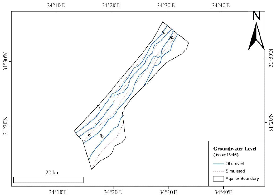
Model calibration and validation: The model was calibrated using the groundwater level map for the year 1935. This map was obtained from Qahman & Zhou [25] (Figure 4). Additionally, the calibrated hydrogeological parameters were acquired from the calibrated model in the steady state condition performed by Dentoni, et al. [3] for the year 1935. The calibration was conducted by dividing the model domains into 11 zones derived from the soil type map generated by Hamad, et al. [26] as shown in Figure 3. Table 3 shows the calibrated hydraulic conductivity for the model.
To validate the model, the transient model was run from the year 1935 until 2010. The model results (groundwater level) were compared with the groundwater level maps for the years 1970, 1990, 2000, and 2010 acquired by Dentoni, et al. [3]. The validation process shows a good agreement between the simulated and the observed values.
Management scenarios: Based on the solution proposed from the previous studies and the plans adopted by the Palestinian Water Authority (PWA) prior to managing the water resources in the Gaza strip, the best solutions involve reducing the pumping rates and injecting water into the aquifer via artificial recharge techniques. However, most studies didn’t consider the feasibility of the scenarios according to the study area situations such as the future possible water supply including water and wastewater infrastructure systems.
Hence, it is necessary to collect data related to the capacity of different water and wastewater infrastructure systems and the required water demand in the study area to calculate the feasible abstraction and recharge rate for the study area. It has been found that water infrastructure in the study area includes desalination plants and recharge basins, where desalinated water and storm water could be used for domestic purposes instead of using groundwater. However, wastewater treatment plants could be applied such that sewage effluent could be used to recharge the aquifer. Table 4 shows the water supply in the study area Table 5.
Based on the available water supply in the study area (desalinated water, stormwater, purchased water), the abstraction of the groundwater for domestic purposes could be reduced to 30 Mm3 by the year 2030. Thus, the reliable abstraction rate could be reduced to around 145 Mm3 instead of 215 Mm3 (the groundwater abstraction rate would be reduced by 70 Mm3). Regarding the artificial recharge, the tertiary sewage effluent could be utilized to recharge the aquifer, where the artificial recharge rate could reach around 50 Mm3 (around half of the treated wastewater).
Four management scenarios were proposed to increase the groundwater level based on the future demand and supply in the study area. The time horizon for modeling the future period was specified from the year 2020 to the year 2040. These management scenarios are developed based on a plan adopted by the Palestinian Water Authority (PWA). The scenarios are demonstrated in Table 6. The simulated groundwater level in the year 2040 is represented in the results section.
Scenario 1 simulates the groundwater level from the year 2020 until the year 2040 without any change in the current situation including reducing the pumping rate (abstraction rate = 215 Mm3) or injecting the artificial recharge to the aquifer (artificial recharge rate = 0 Mm3). In scenario 2, the groundwater abstraction rate will be decreased from the year 2020 until the year 2040 such that the abstraction rate would reach 145 Mm3/yr based on the aforementioned calculations. However, in scenario 3, it has been purposed to install artificial recharge wells and recharge basins along the aquifer distributed all over the study area. The total artificial recharge rate is around 50 Mm3/yr, where the source of the recharge would be Tertiary Sewage Effluent discharged after treatment from the current Wastewater treatment plants in the study area. However, scenario number 4 combines both scenario 2 and scenario 3.
Results and discussions
Model results
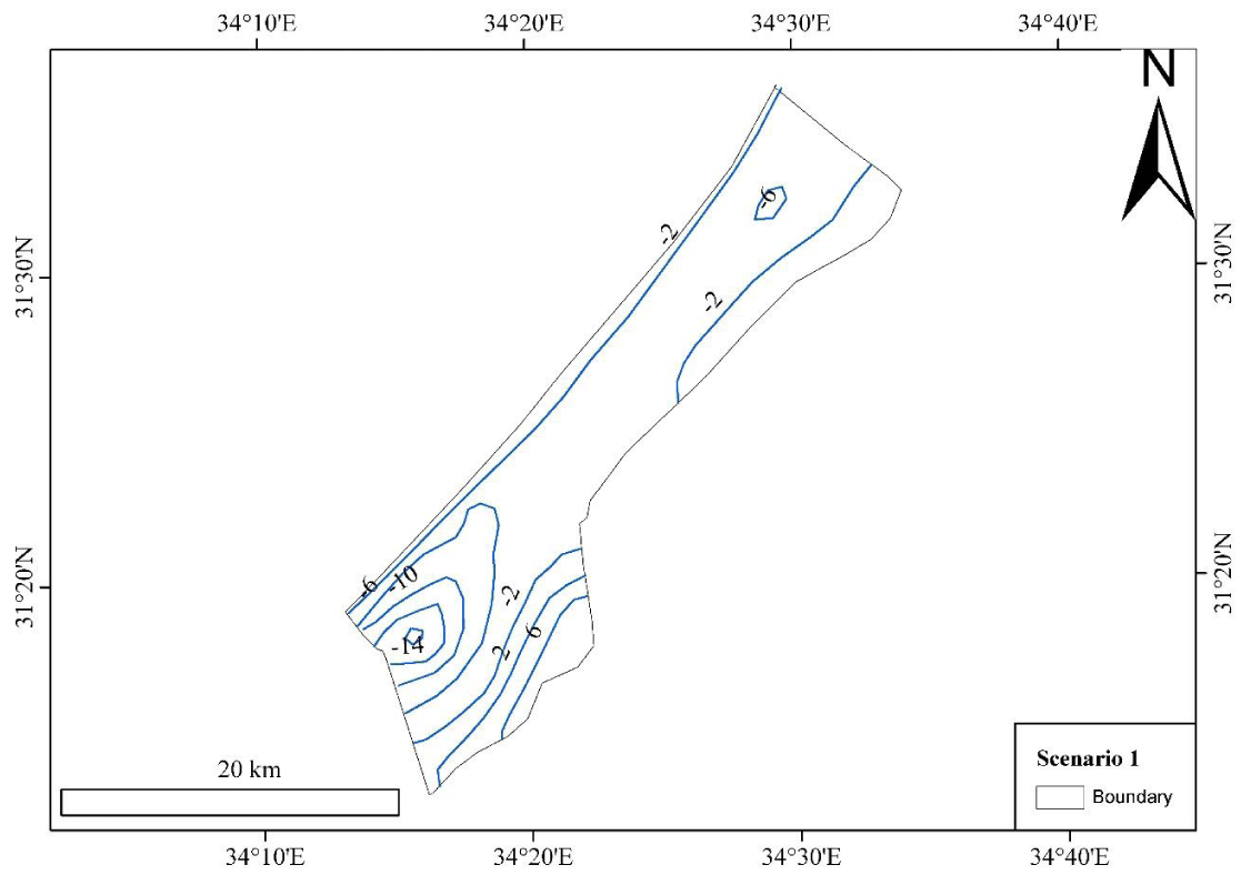
Scenario 1: The first scenario simulates the impact of no reduction of the pumping rate on the groundwater level. It is clearly perceived that 2 cones of depression take place. The first one is located in the northern part of the study area, whereas the second is located in the southern portion. The results show that (as shown in Figure 5) the groundwater level will be declined until the year 2040 reaching respectively around -21 m and -9 m below mean sea level for the southern and northern parts of the study area. The results are different from the latter found by Abualtayef, et al. [9], where the groundwater level will be decreased in 2 depression cones reaching -24 m and -12 m respectively. The reason for this is that the increase in abstraction rate was considered in Abualtayef, et al. [9], however, it wasn’t considered in this study. As Abualtayef, et al. [9] estimated an annual increase in pumping rate by 3.8 % using the assumption proposed by PBCS [27].
The result quite agrees with the latter obtained by Selmi [7] stating that the groundwater table will decrease to more than -16 m below mean sea level in the southern portion and around -9 m in the northern portion. A study conducted by Qahman & Larabi [6] indicates that this scenario causes intruding seawater into the hydrogeological system by a volume of 72 Mm3.
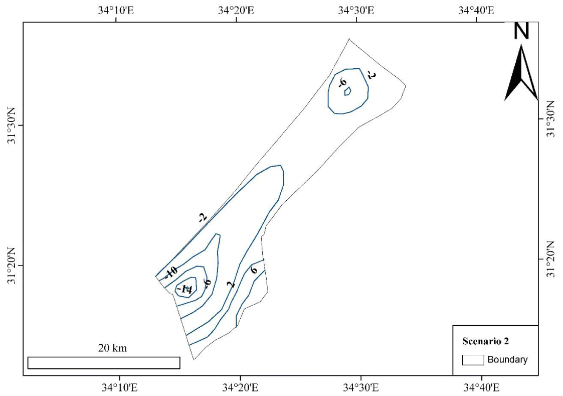
Scenario 2: The results of the second scenario as shown in Figure 6 indicates that reducing the pumping rates to around 145 Mm3/yr until the year 2040 will result in increasing the groundwater level such that the groundwater level at the 2 depression cones are -18 and -6 m. There isqa an agreement between this result and the results obtained by Abualtayef, et al. [9]. The result indicates that enhancement in the groundwater level would occur reaching respectively -18 m and -3 above mean sea level for the southern and northern depression cones. However, Selmi [7] proposed in this scenario to stop pumping from the regions where the depression cone is present. In this situation, the groundwater level could be increased above the mean sea level. Although this assumption solved the problem, it is considered an unrealistic solution, as it is unfeasible to stop pumping where the water demand is not already met such as for agricultural practices and municipal purposes. This solution might be impractical because in the future the demand may reach around 260 Mm3 [7]. Therefore, it is worth important to find other water sources to cope with the deficit that occurs due to this scenario such as using treated wastewater in agriculture and desalinating brackish water.
In this scenario, it was assumed that groundwater exploitation will be reduced to around 145 Mm3. However, Qahman, et al. [12] used a simulation-optimization approach to predict the optimum pumping rate that could achieve high groundwater levels and low seawater intrusion into the aquifer. The results show that the safe yield of the pumping rate ranges from 26% to 34% of the natural replenishment (15 Mm3 to 20 Mm3). This result is considered unfeasible because the pumping rates are not matching the demand needs. Weinthal, et al. [13] suggested that pumping the saline water along the aquifer boundary combined with a decrease in pumping might improve the groundwater quality. The reduction of the pumping will result in a reduction of seawater flux to the aquifer by 40 Mm3 as calculated by Qahman & Larabi [6].
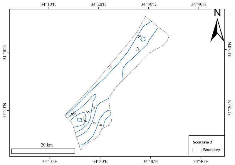
Scenario 3: This scenario indicates installing the artificial recharge without reducing the pumping rate to increase the recharge rate entering the hydrogeological system. As shown in Figure 7, it is clearly noticed that 2 depression cone areas are present in the southern and northern portions of the study area. The groundwater level in these 2 cones is -14 m and -6 m below the mean sea level respectively. The results are quite different from that obtained by Abualtayef, et al. [9]. The depression cone for the southern and northern portions are -18 and -3 m respectively. The reason for the difference could be due to the difference in the artificial recharge rate estimated by Abualtayef, et al. [9] and this study. It has been inferred that the aquifer is responsive to artificial recharge where the hydraulic conductivity is high for injection purposes.
Scenario 4: This scenario follows the PWA plan for restoring the groundwater level and remediating the groundwater quality. As shown in Figure 8, the results show that the groundwater level will be increased above the mean sea level. However, only a depression cone will be situated in the southern part of the study area, where the groundwater level is reaching around -6 m. The results are different from that acquired by Abualtayef, et al. [9], where the groundwater level is above the mean sea level in the systems. The reason might be that the storage coefficient used in this study is different from the ones used in Abualtayef, et al. [9]. This scenario was based on the Coastal Aquifer Management Plan (CAMP) adopted by PWA for the next 20 years.
Scenario evaluation
Table 7 evaluates the system under different proposed scenarios. The table demonstrates that scenario 4 is the best scenario that could be adopted to restore the groundwater level and improve the groundwater quality. As the system deficit would be reduced from 260 % to nearly 30 % and the groundwater level will be increased by around 15 m at the depression cones. Thus, Scenario 4 could be adopted due to its best performance in recovering the system to its stable condition. However, the groundwater level is still less than the mean sea level, leading to intruding seawater into the hydrogeological system. To avoid the seawater intrusion phenomena, the groundwater level should be greater than 0 m (stable condition). To restore the groundwater level, it is necessary to reduce the deficit such that it reaches 0 %. This could be possible after the year 2040 when more wastewater treatment and desalination plants might enter the service.
Conclusion
Gaza strip aquifer is a hydrogeological system that is dynamically affected by different natural factors (seawater intrusion, natural replenishment) and anthropogenic factors (over-exploitation, agricultural pollution). However, the system is in an unstable condition for the past 50 years due to the over-exploitation of groundwater to meet agricultural and domestic needs. Therefore, four reasonable management scenarios were adopted to ensure a steady state balance. To assess the management scenarios, the groundwater level was simulated from the year 2010 to the year 2040. The results are compared with the previous results conducted by several researchers in the study area.
The results show that combining both reducing the abstraction rate and increasing the artificial recharge to the hydrological system might lead to restoring partially the groundwater level to its natural balance by the year 2040. The results are agreeing with the CAMP plan adopted by PWA for the next 20 years to augment the groundwater resources and remediate the groundwater from different pollution sources such as seawater intrusion and agricultural pollution.
To apply the selected scenario, different water sources could be utilized: desalinated seawater treated wastewater, and imported water from outside. Additionally, to reduce the pumping rate, it is preferred to increase the pumping rate around the aquifer boundary to extract the seawater and reduce the pumping rate inside the aquifer. It is clearly noticed that other non-conventional water resources can substitute the groundwater resources in the study area in case the artificial recharge is considered infeasible in terms of cost.
Some limitations are not considered in this study. These limitations include that this study didn’t take into account the effect of sea level rise on the groundwater and the effect of climate change projection on the natural replenishment of the aquifer. Additionally, this study didn’t take into consideration the main contaminants affecting the groundwater such as Chlorine and Nitrate. A cost-benefit analysis should be conducted to study the feasibility of installing artificial and securing water sources for the system.
Besides applying the CAMP plan by the PWA, stringent environmental guidelines, legislation, regulations, and enforcement should be imposed and practiced to ensure applying the plan in an effective and efficient way. Different measures have to be considered including achieving a safe yield in most pumping wells in the study area including the private wells owned by the farmers. Thus, monitoring should be accomplished on regular basis.
Since Groundwater is the only source in the Gaza strip aquifer and it is in an unstable condition, therefore, it is highly recommended to conduct investments to monitor the applied scenario including installing monitoring wells to observe the groundwater levels and concentration of different chemical species such as Chlorine and Nitrate.
- Al-Yaqubi A, Aliewi A,Mimi Z. Bridging the domestic water demand gap in Gaza Strip-Palestine. Water International. 2007; 32(2): 219–229. https://doi.org/10.1080/02508060708692202
- Hamdan SM, Nassar A,Troeger U. Impact on Gaza aquifer from recharge with partially treated wastewater. Journal of Water Reuse and Desalination. 2011; 1(1): 36–44. https://doi.org/10.2166/wrd.2011.001
- Dentoni M, Deidda R, Paniconi C, Qahman K, Lecca G. A simulation/optimization study to assess seawater intrusion management strategies for the Gaza Strip coastal aquifer (Palestine). Hydrogeology Journal. 2015; 23(2):249–264. https://doi.org/10.1007/s10040-014-1214-1
- Melloul AJ, Collin ML. Une approche empirique pour la gestion à long terme des eaux souterraines: Le cas de l’aquifère côtier surexploité de la région de Gaza. Hydrological Sciences Journal. 2000;45(1):147–159. https://doi.org/10.1080/02626660009492311
- Al-yaqubi A.Sustainable Water Resources Management of Gaza Coastal Aquifer , Palestine. The 2nd International Conf. on Water Resources & Arid Environment. 2006.
- Qahman K, Larabi A. Evaluation and numerical modeling of seawater intrusion in the Gaza aquifer (Palestine). Hydrogeology Journal. 2006; 14(5): 713–728. https://doi.org/10.1007/s10040-005-003-2
- Selmi A. Groundwater management and modelling of the Gaza Strip. Retrieved from file:///C:/Users/zainab/Downloads/phd_unimib_725010.pdf. 2013.
- Rahman MA, Rusteberg B, Uddin MS, Lutz A, Saada MA, Sauter M. An integrated study of spatial multicriteria analysis and mathematical modelling for managed aquifer recharge site suitability mapping and site ranking at Northern Gaza coastal aquifer. J Environ Manage. 2013 Jul 30;124:25-39. doi: 10.1016/j.jenvman.2013.03.023. Epub 2013 Apr 18. PMID: 23603773.
- Abualtayef M, Rahman GA, Snounu I, Qahman K, Sirhan H, Seif AK. Evaluation of the effect of water management interventions on water level of Gaza coastal aquifer. Arabian Journal of Geosciences.2017;10(24). https://doi.org/10.1007/s12517-017-3329-x
- Ibraheem A,Saleh A. Impact of Pumping on Saltwater Intrusion in Gaza Coastal Aquifer , Palestine. Water. 2007; 1–88.
- Seyam M, Alagha JS, Abunama T, Mogheir Y, Affam AC, Heydari M,Ramlawi K.Investigation of the influence of excess pumping on groundwater salinity in the Gaza coastal aquifer (Palestine) using three predicted future scenarios. Water (Switzerland). 2020;12(8). https://doi.org/10.3390/w12082218
- QAHMAN K, LARABI A, OUAZAR D, NAJI A,CHENG AHD. Optimal Extraction of Groundwater in Gaza Coastal Aquifer. Journal of Water Resource and Protection. 2009; 01(04): 249–259. https://doi.org/10.4236/jwarp.2009.14030
- Weinthal E, Vengosh A, Marei A, Kloppmann W. The water crisis in the gaza strip: prospects for resolution. Ground Water. 2005 Sep-Oct;43(5):653-60. doi: 10.1111/j.1745-6584.2005.00064.x. PMID: 16149960.
- Abd-Elhamid HF, Javadi AA, Qahman KM. Impact of over-pumping and sea level rise on seawater intrusion in Gaza aquifer (Palestine). Journal of Water and Climate Change. 2015; 6(4):891–902. https://doi.org/10.2166/wcc.2015.055
- Abu Al Naeem MF, Yusoff I, Ng TF, Maity JP, Alias Y, May R, Alborsh H. A study on the impact of anthropogenic and geogenic factors on groundwater salinization and seawater intrusion in Gaza coastal aquifer, Palestine: An integrated multi-techniques approach. Journal of African Earth Sciences. 2019;156(May): 75–93. https://doi.org/10.1016/j.jafrearsci.2019.05.006
- Mushtaha AM, Van Camp M,Walraevens K.Quantification of recharge and runoff from rainfall using new GIS tool: Example of the Gaza Strip aquifer. Water (Switzerland). 2019; 11(1). https://doi.org/10.3390/w11010084
- Ajjur SB. Effects of Climate Change on Groundwater Resources (Northern Gaza Strip Case Study), (December). 2012;1–135.
- Picard L. Structure and evolution of Palestine. Bulletin of Geological Department, Hebrew University, Jerusalem.1943; 4(2): 134.
- Bartov Y,Arkin Y. Regional Stratigraphy of Israel. A guide to geological mapping. Geological survey Israel , current research. 1980.
- Frechen M, Neber A, Tsatskin A, Boenigk W,Ronen A. Chronology of Pleistocene sedimentary cycles in the Carmel Coastal Plain of Israel. Quaternary International. 2004;121(1), 41–52.
- Al-Agha M,El-Nakhal H. Hydrochemical facies of groundwater in Gaza strip, Palestine. Hydrological Sciences Journal.2004; 49(3): 359–371.
- Galili E, Zviely D, Ronen A,Mienis H.Beach deposits of MIS 5e high sea stand as indicators for tectonic stability of the Carmel coastal plain. Quaternary Sciences Reviews. 2007; 26(1): 2544–2557.
- MacDonald MG,Harbaugh AW. A modular three-dimensional finite-difference groundwater flow model. USA.1988.
- Hamraz BS, Akbarpour A, Bilondi MP, Tabas SS. On the assessment of ground water parameter uncertainty over an arid aquifer. Arabian Journal of Geosciences. 2015; 8(12): 10759–10773. https://doi.org/10.1007/s12517-015-1935-z
- Qahman K, Zhou Y. Monitoring of Seawater intrusion in the Gaza Strip, Palestine. In First International Conference on Saltwater Intrusion and Coastal Aqufiers Monitoring Modelling and Management. Essaouira, Morocco. 2001.
- Hamad J, Eshtawi T, Abushaban A,Habboub M. Modelling the impact of land-use change on water budget of Gaza Strip. Journal of Water Resources Protection. 2012; 4: 325–333.
- Palestinian Central Bureau of statistics. Projected population in the Palestinian territory. 2016.
- Dan J,Greitzer Y.The effect of soil landscape and Quaternary geology on the distribution of saline and fresh water aquifer in the Coastal Plain of Israel: Tahal Water Planning for Israel. 1967.
- PWA/USAID. Summary of Palestinian hydrologic data. Palestine: Palestinian Water Authority. 2000.
- World Bank.Securing Water for Development in West Bank and Gaza. Washington, D.C. 2018.
Article Alerts
Subscribe to our articles alerts and stay tuned.
 This work is licensed under a Creative Commons Attribution 4.0 International License.



 Save to Mendeley
